Bathymetric LiDAR Scanning – Accurate Mapping of Shallow Waters and Coastal Zones
Bathymetric LiDAR scanning is a highly efficient surveying technique enhanced by AI-driven analytics and refined through years of Field’s operational experience. By capturing terrain data both above and below the water surface within a single survey, it delivers fast, precise, and seamless mapping—particularly in environments where traditional survey methods are limited, inefficient, or time-intensive.
With extensive experience, we have mapped lakes, rivers, and coastal zones across Europe and internationally, covering thousands of square kilometers for government authorities and private clients. Our portfolio includes large-scale and technically complex projects - some among the first of their kind - which have contributed to Field’s strong reputation and well-established references within the hydrographic community.
Project scales range from targeted surveys supporting marine construction activities, such as cable landing sites, to national and regional coastal zone mapping programmes. Using a green laser and operating at aircraft speeds of around 250 km/h, airborne bathymetric LiDAR enables rapid area coverage while maintaining high positional and vertical accuracy.
The achievable water depth depends on sensor characteristics, water clarity, and local bottom reflectance. With Field’s bathymetric LiDAR sensor, depths of up to three times the visible water depth can be reached under suitable conditions.
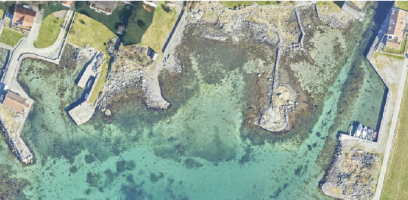
Bathymetric LiDAR data supports flood and erosion assessment, coastal change analysis, and environmental monitoring. In shallow coastal zones, the data links topographic terrain models with vessel-based sonar data, resulting in a seamless topo-bathymetric elevation model of the land–sea interface.
Flexible deliverables and complementary sonar surveys
As airborne bathymetric LiDAR is most effective in shallow areas and sonar becomes more efficient in deeper water, the two technologies are complementary. Field therefore integrates bathymetric LiDAR with multibeam echo sounder surveys where required, ensuring complete and reliable coverage.
Deliverables are tailored to project requirements and typically include point clouds, digital terrain models, elevation contours, as well as orthophotos. This provides a robust foundation for analysis, planning, and decision-making in coastal and freshwater environments.
If you are considering the use of airborne bathymetric LiDAR for your project, please contact us. We are pleased to discuss your requirements and can provide an initial, no-obligation assessment of feasibility and suitability for your survey area.