Nøyaktig kartlegging av grunne farvann og kystsoner
Field er et av få spesialiserte selskaper i Europa som rutinemessig leverer luftbårne batymetriske LiDAR-undersøkelser. Med mange års erfaring har vi kartlagt innsjøer, elver og kystområder over hele Europa og verden, og dekket mange tusen kvadratkilometer for offentlige myndigheter og private kunder. Dette inkluderer flere store og teknisk krevende prosjekter som var blant de første i sitt slag - og hvor Field har drevet frem utviklingen med nye innovative metoder.
Bathymetriske LiDAR-data er et viktig grunnlag for kartlegging av farer som flom, erosjon og jordskred. De støtter sikker prosjektplanlegging, miljøovervåking og beslutningstaking i vassdrag og kystområder.
Prosjektene varierer i størrelse, fra målrettede undersøkelser til støtte for marine konstruksjonsaktiviteter, for eksempel kabellandingssteder, til nasjonale og regionale kartleggingsprogrammer for kystsoner. Ved hjelp av en grønn laser og med en flyhastighet på rundt 250 km/t, muliggjør luftbåren batymetrisk LiDAR rask dekning av området samtidig som den opprettholder høy posisjonell og vertikal nøyaktighet.
Den oppnåelige vanndybden avhenger av sensorens egenskaper, vannets klarhet og lokal bunnrefleksjon. Med Fields batymetriske LiDAR-sensor kan man under passende forhold oppnå dybder på opptil tre ganger den synlige vanndybden.
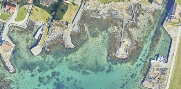
Batymetriske LiDAR-data støtter vurdering av flom og erosjon, analyse av kystendringer og miljøovervåking. I grunne kystsoner kobler dataene topografiske terrengmodeller med sonardata fra fartøy, noe som resulterer i en sømløs topografisk-batymetrisk høydemodell av grensesnittet mellom land og sjø.
Fleksible leveranser og komplementære sonarundersøkelser
Siden luftbåren batymetrisk LiDAR er mest effektiv i grunne områder og sonar blir mer effektiv i dypere vann, utfyller de to teknologiene hverandre. Field integrerer derfor batymetrisk LiDAR med multibeam-ekkoloddundersøkelser der det er nødvendig, for å sikre fullstendig og pålitelig dekning.
Leveransene tilpasses prosjektkravene og inkluderer vanligvis punktskyer, digitale terrengmodeller, høydekurver og ortofoto. Dette gir et solid grunnlag for analyse, planlegging og beslutningstaking i kyst- og ferskvannsmiljøer.
Hvis du vurderer å bruke luftbåren batymetrisk LiDAR til prosjektet ditt, kan du kontakte oss. Vi diskuterer gjerne dine krav og kan gi en innledende, uforpliktende vurdering av gjennomførbarhet og egnethet for undersøkelsesområdet ditt.