Zum Hauptinhalt springen

Dienstleistungen


Punktwolken


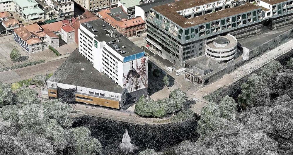
 A point cloud is a highly detailed 3D representation of real-world environments made up of millions — sometimes billions — of individual measurement points. Each point contains precise spatial coordinates (X, Y, and Z), and often additional information such as intensity, color, or classification.  At Field we deliver end-to-end point cloud solutions — from data acquisition to advanced analysis and deliverables. 

Punktwolken


Punktwolken

Technologies 

Point clouds are typically generated using advanced technologies such as:

  • LiDAR (Light Detection and Ranging)
  • Drone-based aerial surveys
  • Mobile mapping systems
  • Terrestrial laser scanners
  • Photogrammetry from high-resolution imagery

When combined, these individual points create an accurate, measurable digital replica of terrain, buildings, infrastructure, vegetation, and other physical features.


What can Point Clouds be used for?

Field delivers Point cloud services that supports a wide range of industries and applications, including:

  • Topographic and terrain modeling
  • Nature loss and environmental change analysis
  • Road analysis
  • Power Line and Electricity Inspections
  • 3D city and infrastructure modeling
  • Construction planning and monitoring 
  • Flood and drainage modeling
  • Forestry analysis
  • Asset inspection and management

Because the data is measurable and spatially accurate, it becomes a powerful foundation for GIS, CAD, BIM, and digital twin workflows.


AI-Powered Solutions

At Field, we leverage artificial intelligence to unlock the full potential of point cloud data. AI algorithms can automate and enhance tasks that are traditionally time-consuming, such as:

  • Classification - Automatically identifying ground, buildings, vegetation, roads, and other features

  • Object Detection - Detecting and mapping poles, power lines, vehicles, or construction equipment

  • Change Detection - Comparing point clouds over time to track construction progress, erosion, or land-use changes

  • Noise Removal & Data Cleaning - Quickly filtering out errors and irrelevant points

  • Predictive Modeling - Identifying patterns or potential risks in infrastructure or natural environments

Our team of geospatial specialists combines years of experience with cutting-edge AI-powered intelligence to deliver highly accurate point clouds and insights.

Get in touch if you would like more information.


Datenerfassung aus der Luft, RGB-Punktwolke, Laserscanning.


Kontakt aufnehmen

Toni Selvli

Schweden

Toni Selvli

Sales Manager, Airborne & Mapping

+46 706 777 649

Lasse Turunen

Finnland

Lasse Turunen

Business Manager, Analytics & Software

+35 850 491 5180


Abbildung_64x64png

Kartierung & Modellierung

Field bietet eine breite Palette von Geodaten- und Kartierungsdiensten an, z. B. Stadt- und Korridorkartierung, fernerkundungsbasierte Waldinventur und standortbezogene Dienste. Wir leben in einer digitalen Welt, in der digitale Modelle von physischen Objekten zum Standard gehören. Planung, Bau und Wartung erfolgen in 3D, was Kosten spart und die Effizienz erhöht. Wir verfügen über umfangreiche Erfahrung in der Verarbeitung von Geodaten zu 3D-Modellen von Städten, Infrastruktur, Gebäuden, Gelände und Meeresboden. Weitere Field Mapping & Modelling Dienstleistungen finden Sie unten.


Geospatial-Lösungen mit Software, Sensoren und KI-Technologien

Helfen Sie mit, präzise Geodaten zu erfassen und in wertvolle Erkenntnisse und digitale Zwillinge umzuwandeln.